Slope Stability Radar
2025-8-15
![]()
![]()
![]()
![]()
![]()
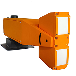
1.1.1. Overview
To meet the emergency response sector's need for promoting compact, rapid, lightweight, and smart equipment at the grassroots level, the product is an all-directional emergency slope radar employing advanced technologies including broadband millimeter-wave FMCW signal system, arc synthetic aperture high-resolution imaging algorithm, phase differential interferometry, and adaptive atmospheric disturbance compensation. It features non-contact remote monitoring, all-weather operation (rain, snow, fog, and low-light nighttime conditions), 360° full coverage, sub-millimeter deformation measurement accuracy, compact and low-power design, onboard edge computing, reliable performance, and low operational costs. Capable of comprehensive slope coverage, it enables grassroots emergency teams to carry and deploy rapidly for continuous monitoring of geohazard sites including small/medium slopes, highway/railway embankments, hydraulic structures, and buildings, providing a cost-effective, rapid-response, and easy-to-maintain monitoring solution.
1.1.2. Main features
High-precision deformation measurement with 0.1mm accuracy and a maximum data refresh rate of 60s, ensuring highly sensitive deformation monitoring;
Strong microwave penetration capability,enabling all-day, all-weather monitoring unaffected by rain, snow, fog or dust;
360°full-coverage monitoring achieved through arc imaging and continuous-wave radar technology;
Edge computing architecture with onboard data processing and built-in wireless router, enabling standalone deployment for rapid setup;
Integrated satellite compass for quick acquisition of device positioning and orientation;
Manually adjustable antenna tilt for flexible monitoring in steep mountainous terrain;
Utra-light weight design adjust 5kg and<0.5m size,allowing single-person portability(hand-carry/backpack);
Low-power operation(≤5Wat 10min update rate),supporting prolonged emergency monitoring missions.
1.1.3. Technical index
Edge Computing Onboard, with Integrated Satellite Compass and Wireless Communication Module.
Max Detection Range :≥1000m
Deformation Accuracy :≤0.1mm(RMS,all azimuths)
Single-Scan Coverage :≥360°×40°
Antenna Tilt Adjustment Range :≥±45°
Range Resolution :≤0.3m(all azimuths)
Azimuth Resolution :≤9mrad(all azimuths)
Data Acquisition Cycle :≤1min
Average Power Consumption :≤5W(10-minute update interval)
Weight:≤5kg
Operating Temperature Range:-40~65℃
1.1.4. Application cases

Anhui Lijian Defense Technology Co., Ltd Copyright 皖ICP备20002291号-1 Disclaimer